Architecture professor leads effort to make water visible

Walk down Newbury Street in Boston’s Back Bay neighborhood anytime between now and the second week of October. If you do, there’s a good chance you’ll come across at least one of 10 Bluetooth-enabled well caps designed to monitor and display groundwater levels in real time.
The well caps are the brainchild of Michelle Laboy, assistant professor of architecture at Northeastern, and they’re helping to make groundwater perpetually visible to city officials and residents alike.
“I’ve always been interested in water’s role in the urban landscape,” said Laboy, a member of Northeastern’s Resilient Cities Lab, “and maintaining groundwater levels in Boston is critical to the preservation of old buildings in some of the city’s most historic neighborhoods.”
The effort—dubbed Project LightWell—is being carried out in partnership with FieLDworkshop, Laboy’s research-based design practice; Conform Lab, a digital fabrication firm; and Boston Groundwater Trust, which was created in 1986 to monitor groundwater levels in neighborhoods where old building foundations are threatened by drawdown. It’s being funded by BGwT, the College of Arts, Media and Design, and Autodesk, the 3D design, engineering, and software company.
How can water once again become a force to productively shape the human experience of urban space?
Michelle Laboy
assistant professor of architecture
Project LightWell is a moving installation, designed to last for one month in each of seven different locations in parts of Boston’s Beacon Hill, Back Bay, Fenway, and South End neighborhoods. Laboy initially installed the well caps along Beacon Street in July, moved them to Commonwealth Avenue in August, and then transported them to Newbury Street earlier this week. Future locations include Boylston Street, Tremont Street, and Columbus Avenue.
The project’s first iteration, which was sponsored in part by the Mayor’s Office of New Urban Mechanics, is located in the South End Library Park. According to Medium, it “consists of two structures that visualize storm water capture in public space by changing computer-controlled lights inside a playful design.” For this one, Laboy strived to revamp the “difficult, slow, manual” process of collecting data on groundwater levels by harnessing the power of technology and citizen science.
Digitally fabricated out of translucent Corian, each well cap houses LED lights and a microcontroller connected to a depth sensor nearly 20 feet below ground level. The sensor continuously reads and transmits groundwater levels via Bluetooth and displays a real-time LED reading to the face of the well cap every hour, informing passersby of the current groundwater level in the area. City residents within 100 feet of the well cap can use the Boston LightWells app—which was created by Laboy, her FieLDWorkshop partner, and a recent graduate of the computer science program—to upload real-time water level readings to the cloud for others to see.
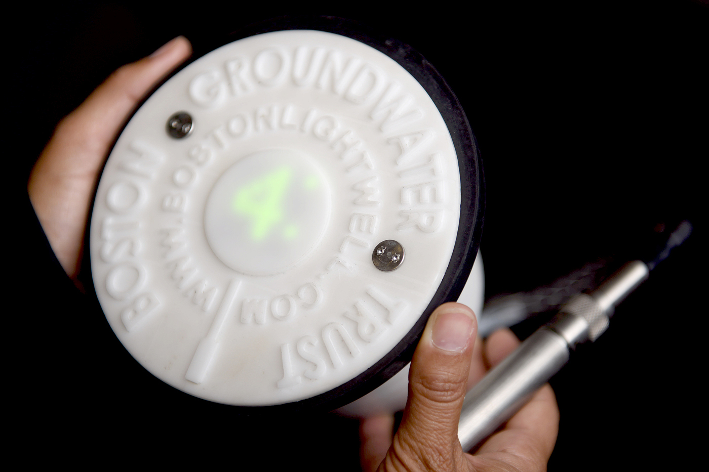
Digitally fabricated out of translucent Corian, each well cap houses LED lights and a microcontroller connected to a depth sensor 30 feet below ground level. Photo by Matthew Modoono/Northeastern University
“Crowdsourcing the data collection is a very powerful way of engaging Boston residents and making them aware of the project,” said Laboy, a self-proclaimed fan of citizen science. “But it also allows the Boston Groundwater Trust to more quickly understand—and react to—fluctuating groundwater levels and their root causes.”
The need for Laboy’s Bluetooth-enabled well caps is acute. According to the Boston Groundwater Trust, nearly all buildings constructed on made land before or during the early part of the 20th century are supported by wood pilings. The pilings will last for centuries if they remain submerged in groundwater, but if groundwater levels drop, the pilings will rot, causing severe foundation problems. “If you’re constantly measuring and keeping track of groundwater levels, you’ll immediately know if a pipe broke or a tunnel is leaking,” said Laboy, citing two factors that commonly lead to drawdown. “Having access to this information enables us to understand what is happening in real time.”
This crowdsourced data will be used to generate interactive maps, with a particular focus on how rain and infrastructure impact the fluctuation of groundwater levels throughout the city’s most historic neighborhoods. Laboy is also working with the Boston Groundwater Trust to find new ways of using her well caps once the 28-week project ends. As she explained, “How can water once again become a force to productively shape the human experience of urban space?”