‘Giving back’ cellphone data so communities can plan
The goal is to help communities better allocate resources, plan for events and more.

It’s a common question among locals whenever there’s a particularly large crowd at a special event or a local tourist attraction: “Where are these people coming from?”
A new online tool from the Social Urban Networks lab (SUNLab) with the Network Science Institute and the Boston Area Research Initiative at Northeastern University may be able to help.
“Communities are not only defined by who lives there,” the teams said in a prepared statement. “They are defined by who shows up, where they come from, and what they do.”
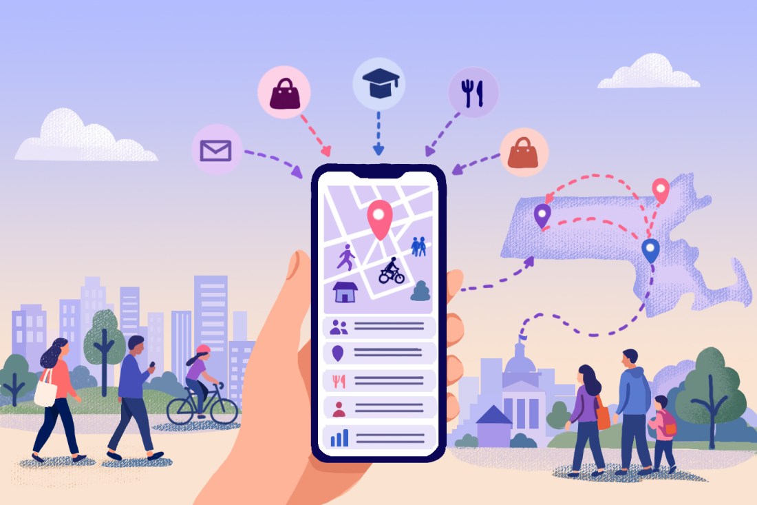
Called Mobility Data for Communities, or MD4C, the tool uses cellphone location data — aggregated and anonymized to protect privacy — to help communities better understand their visitors. The platform reveals such insights as who is coming to different communities, where these visitors come from, can estimate what activities they do in a community, how long they spend there, and more.
“The idea is to create what we call a ‘dynamical census’ in which we show who are the people visiting an area, where they come from, what they do when they are in that area, and how much time they spend, etc.,” said Esteban Moro, a professor of physics and director of SUNLab.
Northeastern Global News, in your inbox.
Sign up for NGN’s daily newsletter for news, discovery and analysis from around the world.
Urban planners, local policymakers and others typically use data from the U.S. Census Bureau to understand their communities and its needs, Moro explains.
But the census has limitations.
While census data is widely available and provides critical demographic information about the people living in a given area, it does not tell us where or when people spend their time outside of the home,” said Sarah Sanchez, a postdoctoral researcher who helped develop the platform. “That’s where mobility data comes in!…It gives community planners information on where people are traveling to and from, and within neighborhoods for activities like shopping, eating, working, and recreation.”

Moro said the goal of MD4C, therefore, is to help communities better allocate resources, plan for events, and more. It was developed in collaboration with representatives of more than two dozen community organizations from Greater Boston, including nonprofits, planning organizations, municipalities and more.
The data that MD4C now makes available is not typically available to communities or nonprofit organizations, said Hamish Gibbs, a postdoctoral student in the lab. He noted that the data requires a certain amount of technical expertise to use, is typically expensive, and often requires complex privacy agreements.
But the team wanted to “give back” the data that communities create, Moro said.
Editor’s Picks


In a demonstration of the tool last week, Moro zoomed in on a map of Massachusetts communities to focus on West Springfield during the Big E, the largest fair on the East Coast, with participants from all over New England. Surrounding communities lit up in a color gradient to show how much of the roughly 200,000 fair attendance they each contributed – the larger the community’s contribution, the brighter green they appeared on the map.
Graphs also compared the demographics of the typical visitors with the demographics of the West Springfield population and estimated which modes of transportation — walking, biking, public transit, car, etc. — visitors were likely to use to get to the fair. Most people, in this case, came by car.
“You can see those events, and you can actually start measuring the impact of events,” Moro said.
Similarly, the tool was able to validate what many locals already know: that Halloween has become more than just a one-night celebration in the city of Salem, and the Seaport’s residents really are generally young, affluent and mostly white or Asian compared with the neighborhood’s visitors who come from throughout Boston.
Such information can help communities better understand local economic activity, plan services and infrastructure, support small businesses, attract visitors and make more informed decisions about future growth, Moro said.
MD4C is still in its initial stages, as data is only available for 2022 and only for communities in Massachusetts. But Moro said that his lab plans to expand the range of the platform’s data collection and geography.
“That will give our partners a whole new idea of what is happening in the area for a long time,” Moro said.