New data tool boosts preparedness for potentially deadly flooding
A new tool spearheaded by Northeastern University interfaces with NOAA’s National Water Model to deliver historic and forecasted flood data to community members involved in flood and emergency preparedness.
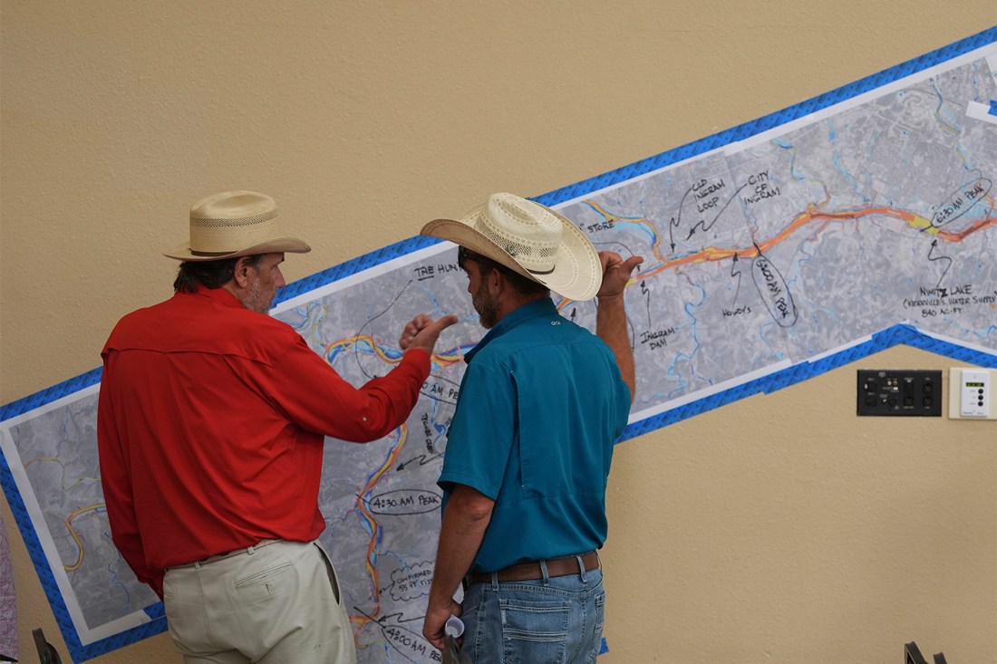

When extreme weather strikes, the preparations of emergency planners can have life-or-death consequences. In July 2025, central Texas flooded with disastrous consequences, killing more than 130 people.
The National Oceanographic and Atmospheric Administration (NOAA) provides a publicly available model that simulates historical and forecasted streamflow for the United States. Unfortunately, many non-technical users have found the model difficult to use.
A new tool spearheaded by Northeastern University’s Global Resilience Institute, in partnership with the Consortium of Universities for the Advancement of Hydrologic Science (CUAHSI), interfaces with the National Water Model to make its data more accessible to non-technical community members involved in flood and emergency preparedness.
The tool
The National Water Model (NWM) collates numerous datasets, including precipitation, soil moisture and water table data to simulate the complex water cycle of the U.S. Hydrologists use this data to understand the complex movements of water across the country, says Daniela Rincon Reyes, a senior research associate at Northeastern.
Called FloodSavvy, the new platform presents the NWM’s data in a more user-friendly and accessible format, Rincon Reyes says.
“We’ve messed around with the National Water Model in the past,” says Michael Busekrus, superintendent of Roaring River State Park, one of the communities that has deployed FloodSavvy. The NWM is incredibly powerful, he continues, however, “you almost need to be a hydrologist, meteorologist to understand it.”
The development, funded by NOAA, took three years, Rincon Reyes says. Research scientists in Northeastern’s Global Resilience Institute led community engagement efforts by conducting interviews with community members in flood-prone regions across the U.S.
“We wanted to really match the community needs” with the features FloodSavvy could provide, she continues, like a straightforward interface and easily accessible historical data.
CUAHSI led the technical development of the project, including processing NWM data to develop the FloodSavvy software.
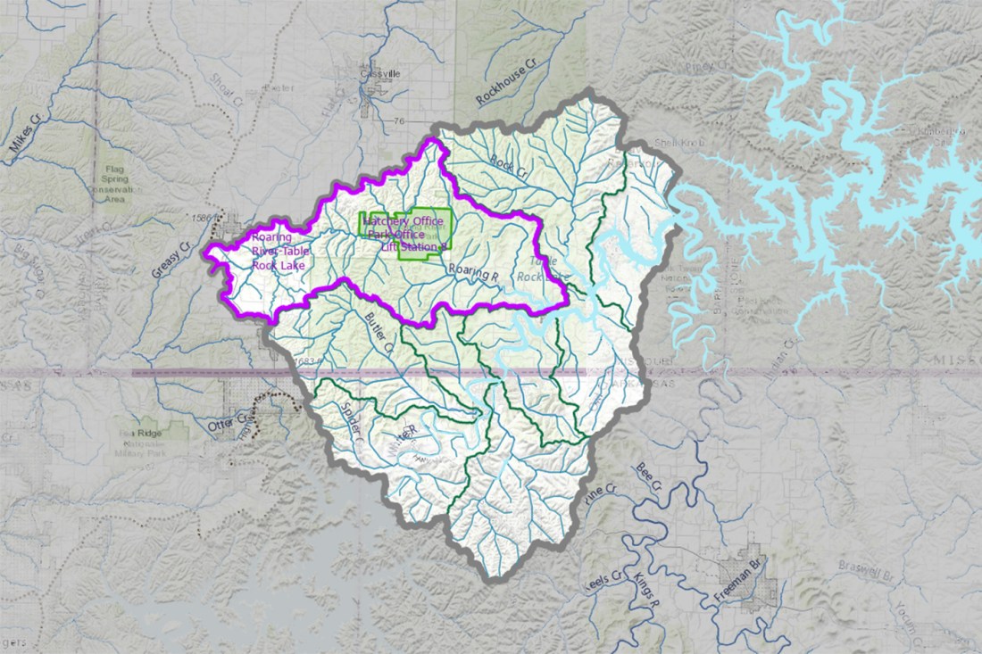
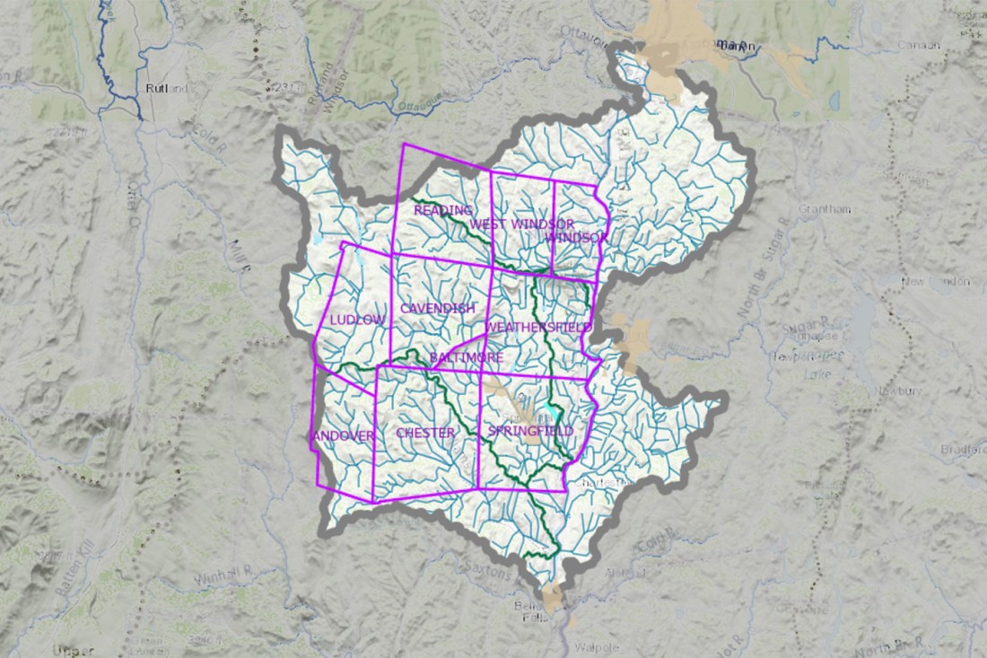
To really understand how community resilience planning occurs in practice, Rincon Reyes says, the FloodSavvy researchers narrowed their focus to six communities, three in Missouri and three in Vermont.
The communities
One of those regions is Roaring River State Park, tucked into the southwest corner of Missouri, covering nearly 5,000 acres of forest and watershed. Busekrus says Roaring River contains numerous narrow creeks and hollows that can funnel huge amounts of water.
Fed by a spring that releases over 20.4 million gallons of water per day, Roaring River is susceptible to flooding even on sunny days when rain occurs somewhere upstream, Busekrus says. The narrow creekbeds and hollows, which locals call “hollers,” can quickly become their own raging tributaries.
In the days before a likely flooding event, Busekrus typically receives decision support packets from the National Weather Service. After these come in, “that’s where I’m inserting FloodSavvy,” he says.
FloodSavvy makes the NWM more understandable and accessible to staff, he continues. Busekrus uses it as a training tool for maintenance staff and to inform his decisions about deploying personnel, whether as monitors of a river’s current height or to preemptively move campers to higher ground.


Rincon Reyes is careful to note that FloodSavvy isn’t meant as a replacement to the NWM, and that it shouldn’t be used in isolation, but its streamlined data presentation can help in the decision-making process.
Kristin Raub, senior research scientist and the principal investigator on the project, says the chosen communities in Missouri and Vermont materialized through a combination of particular need and circumstance. Raub got involved with MoHIC, the Missouri Hydrology Information Center, through a series of research relationships, and Raub lives in Vermont, though not in one of FloodSavvy’s targeted regions.
Margo Ghia, the natural resources planner for the Windham Regional Commission in Vermont, says that floods are the “biggest hazard that Vermont faces” regularly. The Windham Regional Commission helps local municipalities in their hazard mitigation plans.
Ghia finds that FloodSavvy is a valuable tool in developing and communicating these plans at the local level, where communities lack staff with the training to fully utilize the NWM.
The input from these communities, Raub says, was vital in helping the researchers develop FloodSavvy to ensure it would meet their needs.
The National Water Model wasn’t designed for boots-on-the-ground work, she says, “like our regional planning commissions in Vermont.” FloodSavvy provides a lower barrier to entry.
Rincon Reyes says the different stakeholder groups each had different needs that FloodSavvy could meet, from training staff to educating community members moving into the area who might not be aware of historic flooding trends. One group in Vermont, she says, wanted access to FloodSavvy data to support infrastructural funding applications to better prepare for future floods.
The future
Rincon Reyes says that FloodSavvy is providing a model for future work of this kind, bringing together hydrologists and social scientists.
Emma Hibbert, a senior research associate in the Global Resilience Institute who worked on the project, says creating “science that’s usable” was rewarding for everyone involved. She describes how scientists are trained to do research, but finding real-world applications is often difficult.
Many of the people she interviewed making flood preparedness decisions in Vermont at the local level, she says, were volunteers. “Understanding the actual context which they’re working in, and how important it is to have tools that can easily fit into that context, is super important.”
Hibbert began at the Global Resilience Institute as a co-op student during her master’s degree work at Northeastern.
“It was a cool project because it brought together so many different resources,” Busekrus says. The mix of specialties and collaborative environment that led to FloodSavvy, he continues, “speaks for what these collaborative projects can do.”
Meanwhile, Ghia hopes that FloodSavvy will continue to be developed and refined, and made “even more accessible to a broader audience, and more of a go-to tool for emergency and hazard mitigation planning.”
But what about for all those other communities susceptible to flooding that FloodSavvy doesn’t yet cover? Raub has big dreams — and questions that need to be answered. Could FloodSavvy resources be copied and pasted to other flood-prone regions? The diversity of use cases makes that uncertain, she says.
“If you build it with somebody, they’re more likely to use it,” she notes.
The FloodSavvy team has also created both video and text tutorials teaching individuals how to use the NWM. She hopes that, as others are inspired by the ways these six communities use FloodSavvy, they can use the tutorial to better utilize the NWM on their own.