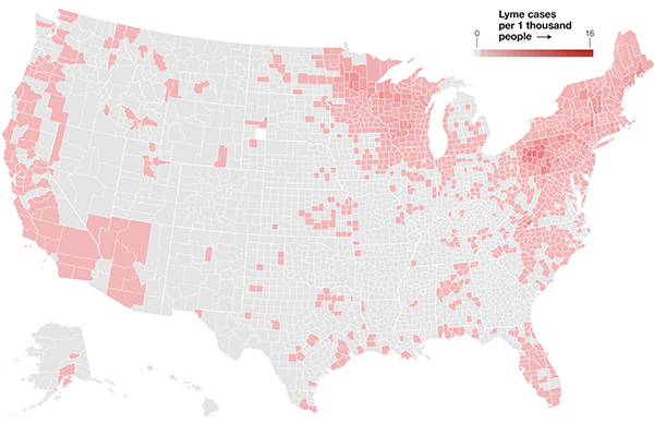
How prevalent is Lyme disease where you live? Find out with this interactive map.

Rashes. Fatigue. Swollen joints.
These are not the ingredients for a happy summer day. But they are the most common symptoms of Lyme disease, a tick-borne illness transmitted by deer ticks that have been infected with the bacteria Borrelia burgdorferi.
Mosquito, flea, and tick-borne illnesses in the United States tripled from 2004 to 2016, according to a new report from the Centers for Disease Control and Prevention. Massachusetts is one of the 14 states where, according to CDC, 95 percent of Lyme disease cases were reported in 2015. Experts estimate that 87,000 people per year in Massachusetts are infected with the bacteria Borrelia burgdorferi, which causes Lyme disease.
Thanks to increasing urban and suburban sprawl, forests are being parceled into smaller pockets of vegetation, said Northeastern University Distinguished Professor of Biology Kim Lewis, who directs Northeastern’s Antimicrobial Discovery Center. Parks and backyards in the suburbs are now the perfect size to sustain mice, but not quite large enough to sustain foxes. That means mice can run rampant with no natural predators to keep their population at bay. And with mice, come ticks.
“The sprawling of suburbia is a fairly recent phenomenon,” Lewis said. “You get more hosts for the ticks, and of course, you get more ticks.”
As the clock ticks closer to summer and the height of tick season approaches, check out our interactive map to see the prevalence of Lyme disease in your state.


